REAL ESTATE SERVICES
Mortgage Loan Inspection Plan (M.L.I.P.)
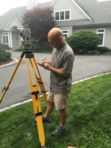
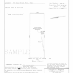
If you are buying or refinancing a home and intend to borrow money, chances are your lender will require a Mortgage Loan Inspection Plan (often called a Class D Survey or Plot Plan). Lenders use this tool to insure title for the mortgage you intend to create. At Livingston-Hughes Surveyors we have completed more than 55,000 of these types of inspections. In order to perform the inspection we examine the legal description for the subject property then search the “face of the earth” for monuments that are described in the deed. A sketch is prepared showing the house and basic improvements, encroachments, easements or rights-of-way to the property. Certifications are then made regarding compliance with local/municipal setback requirements and whether the property is located within the Special Flood Hazard Zone per the Flood Insurance Rate Maps prepared by FEMA (Flood Emergency Management Agency).
A few things to consider:
- A Mortgage Loan inspection is not a Boundary Survey. It should never be used for construction or boundary line determinations. Why? Because no deeds research is performed. We use only the deed provided to us by the lender/title company.
- Monuments are never set in connection with a Mortgage Loan Inspection.
- No appointment is necessary and no one needs to be present for us to complete this kind of Inspection. All field work is performed outside the home and is completed in approximately 45 to 60 minutes.
- The majority of Mortgage Loan Inspections are ordered by the title company, title attorneys and/or Lenders directly involved a given real estate transaction. We go the extra mile to complete these inspections in a very efficient and timely manner so your closing can happen without delay.

To order a mortgage loan inspection, please fill out our online MLIP form by following the button below. Our staff will review the request and contact you as soon as possible. If you have any questions, please email emily@livingstonhughes.com
Flood Elevation Services
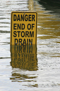 When applying for a home loan, the lender will request a flood certification from one of the national flood certification companies. These large national companies deal only in two dimensions. Because they never visit your property they have no way of understanding the specific geography and topography of your particular site. If the flood certification indicates that the home is in the special flood hazard zone you may want, or need, to order a Flood Elevation Certificate.
Flood Elevation Certificate (F.E.C.)
An Elevation Certificate compares a property’s elevation data to the base flood elevation data established by FEMA. Livingston-Hughes Surveyors will visit your property and make field measurements using survey instruments and techniques to obtain the property’s elevation data. That data is then transferred to the Certificate; the official form of the National Flood Insurance Program. It would be our pleasure to give you a free estimate and answer any questions you may have. Feel free to contact us with questions.
All of us saw the catastrophic results of hurricane Katrina in 2005. FEMA (Federal Emergency Management Agency) says; “Floods are one of the most common hazards in the United States.” Anyone who owns a home in or near an area prone to flooding should ask the question “Is my home at risk for flooding?” Most homeowners want the peace of mind that comes from knowing they are appropriately insured. At the same time, no one wants their insurance company to err on the side of caution and charge a large premium for flood insurance when they do not need it. Elevation Certificates are used to rate your buildings; it can be key document used to ensure exclusion from flood insurance through the Letter of Map Amendment (LOMA) process.
Letter of Map Amendment (L.O.M.A.)
An application for Letter of Map Amendment can be filed with FEMA to request exclusion from the flood program. Unlike the Flood Elevation Certificate, which must be completed by a land surveyor or engineer, a LOMA application is free and the system is designed for the homeowner to file themselves. Livingston-Hughes Surveyors can provide tips to guide you through this process, or we can be hired to file the LOMA application for you. Most LOMA applications are accompanied by a Flood Elevation Certificate. Please visit www.fema.gov to view information required to complete this application.
.
Legal Description
The legal description is the portion of your deed that describes the geographical location of the real estate for the purpose of identifying the property for legal transactions. A legal description of the property identifies the location, boundaries, and any existing easements on the property. If you are involved in real estate transaction or have created a new lot through a division, we can create a legal description for you for inclusion in the deed prepared by your attorney.